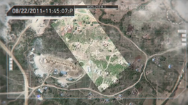
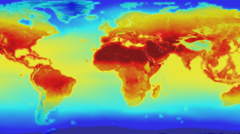
Sangram Ganguly, a senior research scientist at the NASA Ames Research Center shares how they are analyzing satellite imagery with deep learning to gain a better understanding of our planet.
As a founding member of NASA Earth Exchange (NEX), which utilizes NASA’s GPU-accelerated Pleiades supercomputer, Ganguly helped develop the collaboration platform that combines state-of-the-art supercomputing, Earth system modeling, workflow management, NASA remote sensing data feeds, and a social networking platform to deliver a complete work environment in which users can explore and analyze large datasets, run modeling codes, collaborate on new or existing projects, and quickly share results among the Earth science communities.
“We recently got the DGX system which is extremely, extremely useful for us because we have complex (convolutional neural network) models,” said Ganguly because satellite images are getting larger and larger – about 1GB per image. “When we want to stack several of those models, we need a high-memory, big GPU machine.”
Share your GPU-accelerated science with us at http://nvda.ws/2cpa2d4.
Watch more scientists and researchers share how accelerated computing is benefiting their work at http://nvda.ws/2dbscA7
Developer Spotlight: Earth Science Monitoring with Satellite Imagery
Mar 01, 2017
Discuss (0)
Related resources
- GTC session: Transforming 2D Imagery into 3D Geospatial Tiles With Neural Radiance Fields
- GTC session: Using Next-Generation Geospatial Applications and 3D Visualizations to Improve Climate Risk Resilience Strategies
- GTC session: Enabling 3D Geospatial Workflows for Industrial Digital Twins
- NGC Containers: MATLAB
- SDK: IndeX - Amazon Web Services
- SDK: IndeX