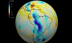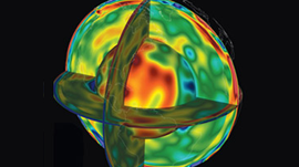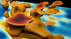
A team of researchers led by Jeroen Tromp at Princeton University used a GPU-accelerated supercomputer to create a detailed 3D picture of Earth’s interior.
“This is the first global seismic model where no approximations — other than the chosen numerical method — were used to simulate how seismic waves travel through the Earth and how they sense heterogeneities,” said Ebru Bozdag, a coprincipal investigator of the project and an assistant professor of geophysics at the University of Nice Sophia Antipolis. “That’s a milestone for the seismology community. For the first time, we showed people the value and feasibility of running these kinds of tools for global seismic imaging.”
Using advanced modeling and simulation, seismic data generated by 253 earthquakes scattered worldwide and 18,688 Tesla GPUs on the Titan supercomputer at Oak Ridge National Laboratory, the researchers imaged the entire globe from the surface to the core–mantle boundary, a depth of 1,800 miles.
For the next part of the work, the team is preparing for Summit, ORNL’s next high performance supercomputer that will be five times the computing power of Titan.
The team’s next model will introduce anisotropic inversions, which are calculations that better capture the differing orientations and movement of rock in the mantle. This new information should give scientists a clearer picture of mantle flow, composition, and crust–mantle interactions. They also plan to simulate higher-frequency seismic waves, which will allow the team to model finer details in the Earth’s mantle and even begin mapping the Earth’s core.
Read more >